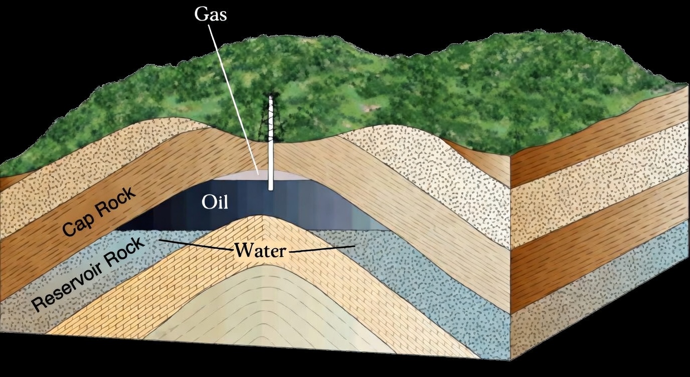
Geologists first study regional and local geological characteristics of sedimentary basins, because hydrocarbons are formed and stored almost exclusively in sedimentary rock formations. This work involves analyzing rock stratigraphy, structural features such as folds and faults, and the depositional environments in which sediments accumulated. These geological factors help determine whether the essential elements of a petroleum system are present: a source rock capable of generating hydrocarbons, reservoir rock with sufficient porosity and permeability to store fluids, a sealing rock to prevent escape, and a structural or stratigraphic trap that allows hydrocarbons to accumulate.
The process also involves reconstructing the geological history of a basin to understand how organic material was deposited, buried, and thermally matured over geologic time. Organic rich sediments subjected to increasing temperature and pressure during burial undergo chemical transformation that generates hydrocarbons. Petroleum geological exploration therefore includes evaluating the maturity of source rocks and assessing whether generated hydrocarbons could have migrated into suitable reservoir formations and remained trapped.
To support these evaluations, geological exploration commonly integrates surface geological mapping, subsurface data obtained from drilling and well logs, and geophysical methods, particularly seismic surveys that provide images of subsurface structures. By combining these datasets, geologists build geological models of the subsurface that indicate locations where hydrocarbons may have accumulated. These interpretations guide exploratory drilling, which ultimately confirms whether petroleum is present.
Geology Exploration Process
Data Collection - Petroleum geological exploration begins with the systematic collection of geological and geoscientific data about a sedimentary basin. This includes regional geological maps, stratigraphic studies, previous well records, core samples, outcrop observations, and published research describing the basin’s tectonic history and depositional environments. The purpose is to determine whether the essential elements of a petroleum system, source rock, reservoir rock, seal, and trapping structures may exist within the basin.
Geophysical Surveys - Geophysical surveys are conducted to investigate subsurface structures that cannot be directly observed from the surface. The most widely used method is seismic reflection surveying, in which artificially generated seismic waves travel through the subsurface and reflect off geological layers, allowing geophysicists to construct images of rock strata and structural traps. Additional methods such as
gravity and magnetic surveys may also be used to infer variations in rock density and magnetic properties that help delineate basin structure and large-scale geological features.
Exploratory Drilling - Exploratory drilling is performed to directly test geological and geophysical interpretations by drilling a well into a suspected hydrocarbon bearing formation. During drilling, rock cuttings and sometimes core samples are retrieved and analyzed to identify lithology,
porosity,
permeability, and the presence of hydrocarbons. This stage provides the first direct evidence confirming whether
oil or natural gas exists in the targeted subsurface formation.
Well Logging & Data Interpretation - After or during drilling, well logging tools are lowered into the borehole to measure physical properties of the surrounding rock formations. Common logs include electrical
resistivity, gamma-ray,
density, neutron, and sonic logs, which help determine rock type, fluid content, porosity, and formation thickness. Geologists and petrophysicists interpret these measurements together with core and drilling data to identify reservoir intervals and evaluate whether hydrocarbons are present in economically meaningful quantities.
Reservoir Evaluation & Economic Assessment - If hydrocarbons are detected, the reservoir is evaluated to determine its size, quality, and production potential. This evaluation uses geological interpretation, petrophysical analysis, pressure testing, and sometimes additional appraisal wells to estimate reservoir properties such as porosity, permeability, fluid saturation, and reservoir extent. The technical results are then combined with
engineering and economic analyses to determine whether the hydrocarbon accumulation can be produced commercially under current technological and market conditions.
 Geology exploration is the scientific and technical process used to identify, evaluate, and locate subsurface accumulations of hydrocarbons, primarily crude oil and natural gas within the earth’s crust. It is a multidisciplinary activity within the field of petroleum geology that integrates principles from geology, geophysics, geochemistry, and reservoir engineering to determine whether geological conditions are suitable for the generation, migration, trapping, and preservation of hydrocarbons. The primary objective is to discover economically recoverable petroleum resources by analyzing the structure, composition, and history of sedimentary basins.